I do not think that any work I have done has brought me as much abuse as that on the transfer of 6,000 square miles of Scottish sea to England in 1999, effected by New Labour by Order in Council literally the day before the Scottish Parliament came into being.
Some of this criticism has been utterly bizarre, including a strange contention that the whole thing did not happen and the legislation does not exist. A marginally more rational criticism has been the contention that the new boundary – which at its extreme limit eastwards runs north of Carnoustie – reflects a genuine median line influenced by the shape of the coastline.
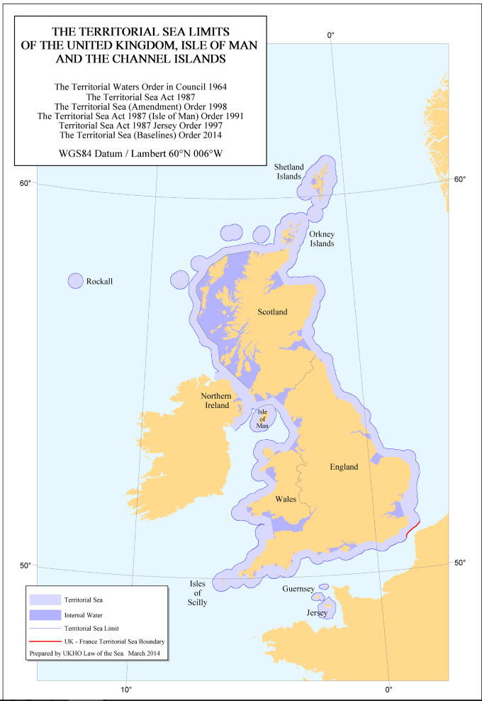
With thanks to this map kindly sent by Dave Philip, I wish to explain why the new boundary is not legitimate.
I do urge you to pay attention. This is important but complex.
This map shows internal waters and the territorial sea. Internal waters are, for legal jurisdictional purposes, land. The territorial sea extends for twelve miles and the law of the coastal state applies within this area. There are two further zones not shown on this map. The Exclusive Economic Zone extends for 200 miles or to a boundary with another state, and as the name says confers on the coastal state the exclusive right to the resources of the sea and seabed. Beyond that can stretch the continental shelf, where the seabed mineral resources are still available to the coastal state where there is a geological continuation.
The area of England/Scotland potential dispute is in the North Sea and relates particularly to the Exclusive Economic Zone. This simply extends out much further than the territorial sea but on the same contours. It is not shown on this map but the baselines from which it is measured are.
The Territorial Sea and Exclusive Economic Zone are measured out from the coastline. But where a coastline is either a) archipelagic or b) highly indented, the coastal state is entitled under the UN Convention on the Law of the Sea to draw straight baselines between coastal points and measure its territorial sea/exclusive economic zone from those baselines rather than from the coast.
This is the key point at issue here. The extraordinary northward trend of the 1999 England/Scotland is caused solely by the massive indentation of the Lothian coastline as it curves into the Firth of Forth. Now look closely at the map. In Western Scotland, there are straight baselines in places far out to sea, and huge areas of sea are designated as “internal waters”. By comparison, in Eastern Scotland the straight baselines are extremely small and conservative by international standards and very little sea is designated as internal water.
The Western baselines have almost no impact on the Scottish/England boundary because of the position of Northern Ireland. But in the North Sea, where they would impact massively on the England/Scotland border in Scotland’s favour, they take a markedly minimalist approach in stark contrast. Remember, we are talking about the Exclusive Economic Zone not shown on the map. extending out 200 miles from the baselines.
After independence I would make a maximalist claim and draw a straight baseline from Eyemouth to Peterhead, enclosing the highly indented coastline. Then measure and delimit the seas from there. This would straighten the England/Scotland border back towards the traditional East West alignment. In so doing, I would make plain that this would not involve any claim to push the outer limits of Scottish seas further or to adjust the boundary with countries across the North Sea; it would merely affect the angle of the England/Scotland border and where the England/Scotland border strikes the tripoint. I would be prepared to pull back that baseline a bit in negotiation. I am a former Head of the Maritime Section of the Foreign and Commonwealth Office and have actually negotiated maritime boundaries for the UK in real life. These things are very much a negotiation, which infuriates the academics who like to believe they are issues of pure geometry.
There are two other points worth considering:
1) The UK has never claimed international boundaries are a matter of pure geometry. Its boundaries are always officially characterised as a modified median line, to acknowledge the give and take of negotiation.
2) The UN Convention on the Law of the Sea does not mandate that the boundary has to be a median line. Other factors may be taken into account including historical jurisdiction. This is a major further argument in Scotland’s favour.
I apologise for the length and detail of this, but the facile and ill-informed criticism had become somewhat annoying.
Craig, this is an interesting take on the situation.
However, I was led to believe that the boundary line has changed once before and that the original line was drawn from the border between Scotland and England (River Tweed).
The line would be drawn based on the direction in which the Tweed flows into the North Sea. From recollection and good old guesswork, this would be an almost 60 degree shift to the south give or take.
It might only give us an extra 5% of the oil rights in the North Sea but since when should we be giving away something for nothing! That is the Tory Mantra after all.
Come Independence, we will be needing your knowledge & advice Mr. Murray ……. an excellent article by an expert.
Recommend that a little light reading on “United Nations Convention on the Law of the Sea”. The key to starting is the Territorial Sea.
http://www.un.org/depts/los/convention_agreements/texts/unclos/unclos_e.pdf
The UK has followed the conventions.
Typical Westminster tactics to keep us from our own destiny
@Mark G. The drone swarm that has been released for the first time is worrying as it adds a new class to this new totally unregulated weaponry and my guess is that we can expect underwater drone swarms as well.
Very likely they will be undetectable, possibly sleepers who stay at a certain depth until their batteries run low, only to resurface and charge them up with solar energy.
It is in the interest of the UK to either abandon this expensive upgrade of a missile system which is obsolete, except in the case of an all out nuclear war, or to instigate and support calls for an international regulation of these kind of weapons.
That Israel, much involved in developing and building this kind of delivery systems will ignore such a call, as it has most others, is a given.
So why do we still have to negotiate with UK when the boundaries lawfully are still within Scotland. Especially when the change of boundaries were moved through the back door by Blairites. To be honest by the time we receive our Independence, it looks like it will take millions to re-establish our oil wells.
One more time.
The line on the map is not the border between Scotland and England.
Nothing was moved through the back door by Blairites, limits of fisheries protection was openly discussed at Westminster by a cross party committee which included Scottish MPs and then approved by the Scottish Parliament.
It’s an example of fake news, completely fabricated but people believe it because they want to.
The Scottish Adjacent Waters Boundaries Order (S.I. 1999/1126) was made under the Scotland Act 1998 which is the year before the Scottish Parliament was re-convened.
Unionist MSPs voted down SNP amendment submitted by Richard Lochhead “calls upon Her Majesty’s Government to amend the Scottish Adjacent Waters Boundaries Order (S.I. 1999/1126) made under the Scotland Act 1998 so that the East Coast boundary is redrawn to a line of latitude due east of the termination point of land border between England and Scotland to re-establish the custom and practice of former years.”
Scottish MSPs, the elected representatives of the people of Scotland, the people we voted for to represent us in parliament voted on the issue and decided not to back the SNP amendment.
That is democracy.
I think its comical that you firstly state this article is fake news, then you go on to present Unionist votes backed by the Unionist UK Media as a valid argument…Fred, dont you have somewhere else to troll?
Scottish Independance today, – Let’s Vote.
Bring it on.
Before devolution and the advent of the Scottish Parliament there was only one legislature making laws and regulations concerning the sea around the UK and what lies under it. Therefore an Anglo-Scottish maritime border was an afterthought and as such a line on the map parallel to the equator was deemed sufficient.
With the advent of devolution and possible expansion of devolved matters, two legislatures would likely be making laws and regulations concerning the seas around both Scotland and England.
It is very likely the Anglo-Scottish maritime border was adjusted to reflect usual international practice in such matters.
The 1999 maritime boundary looks more or less like those suggested in the 2001 paper ‘Prospective Anglo-Scottish maritime boundary revisited’ by Zahraa, M in the European Journal of International Law;2001, Vol. 12 Issue 1.
That would perhaps explain why the SNP leadership never raised the issue. They’d look very silly questioning a maritime boundary that is more or less what international legal precedent would arrive at. Of course, the more or less would still be negotiable if Scottish independence were to occur.
http://connection.ebscohost.com/c/articles/4509673/prospective-anglo-scottish-maritime-boundary-revisited
http://www.ejil.org/pdfs/12/1/505.pdf
Jack, the links you provided are the same as the one I did previously, the paper by Zahraa. There’s just the one map on that paper – and all three lines are proposed ones. None of them are the actual existing one. The existing one from the 1999 goes much further north, which is the whole point of this article. Here it is:
https://marinescotland.atkinsgeospatial.com/nmpi/default.aspx?layers=466
https://marinescotland.atkinsgeospatial.com/nmpi/default.aspx?layers=466
That’s the existing maritime boundary map. Just to make it totally clear, that goes up at about 060° for probably 12 nm, then slopes up northwards to about 045° for around 24nm before curving around eastwards until it goes due East – 090°.
It should go up at about 060° for 12nm, then due east 090° for the remaining 188nm.
Getting a bit bugged by this so I’ve done a map showing existing maritime boundary line, and “proposed” boundary line. There are small variations of the proposed one, but the map shows the huge area “stolen”.
https://yesindyref2.files.wordpress.com/2017/01/median6000.jpg
yesindyref2
Good Work..
It’s Amazing how few Scots Knew of this..Before Craig’s Posts.. in the last few years..yet the deceit is over 20 years old..
Talking of Craig’s posts on this ..’the Stolen Seas’ Video is going on 53,000 Views.
Thanks. Didn’t take that long, used a window capture. I added an acknowledgement on it (original URL) and may have screwed up the wordpress upload so new URL is:
https://yesindyref2.files.wordpress.com/2017/01/stolen6000.jpg
For reference, 1 nm = 1.15 statute mile (normal ones!), 12 nm = 13.8 miles, 200 nm = 230 miles.
I’m even annoying myself. Did a better one with the territorial 12nm actually to scale via pixels and pythagorus, and a subtle caption in red:
https://yesindyref2.files.wordpress.com/2017/01/stolenseas6000.jpg
Very unlike you.. But cool..and thank you
Indeed 🙂
Anyone is welcome to copy the image, edit, chop off the left-hand bit, use, tweet, link or stick in articles. It is just one of a load of possible end negotiations.
This was a last ditch attempt by Blair and tge prospective new labour first minister Donal Dewer to head of any attempts by the new Scottish Parliament to seek independence. In the same way the voting system for the Parliament was designed to stop the SNP ever getting a majority in that Parliament
Is there no limit to the money Scottish politicians want to waste?
http://www.bbc.co.uk/news/uk-scotland-scotland-politics-38602868
more MSP’s “needed”
“I would make plain that this would not involve any claim to push the outer limits of Scottish seas further or to adjust the boundary with countries across the North Sea; ”
This rather weakens your case as the agreed limits with Norway, Denmark, and Germany have already used the UK’s territorial baselines.(low water) on the east coast of England and Scotland.
A year ago, 29 SNP and 2 independent MPs (Michelle Thomson and Natalie McGarry) signed an early day motion stating;
“That this House recognises that the Scottish Adjacent Waters Boundaries Order 1999 is considered irreconcilable with international law and the intent of Article 38 of the Statute of the International Court of Justice (ICJ), and inconsistent with precedent established through the Anglo-French Arbitration, 18 ILM (1979), the Iceland-Jan Mayen (Norway) Conciliation, 20 ILM (1981), the Tunisia-Libya Case, ICJ Reports (1982); the Gulf of Maine Case, ICJ Reports (1984), the Libya-Malta Case, ICJ Reports (1985) and the Guinea-Guinea Bissau: Dispute Concerning Delimitation of Maritime Boundary, 25 ILM (1986).”
The full list of signatories is here; https://www.parliament.uk/edm/2015-16/949
It’s not surprising that Scotland’s 3 unionist MPs did not sign it but why did nearly half of the SNP MPs also fail to sign this early day motion?
I can’t find any record of the Early Day Motion having been debated. This is not unusual as very few Early Day Motion’s are debated but what follow-up action are the SNP MPs taking?
Michelle Thomson and Natalie McGarry
aren’t this pair both under suspicion?
Probably significant that both Angus Robertson and Alex Salmond’s were not signatories. Maybe they were better advised.
I’m always a bit wary of early day motions, that’s what killed Elvis Presley.
All this crap about stolen territory is just Nationalist propaganda, none of it stands up to scrutiny.
What is frightening is that any retard can wave a flag and sing Scotland the Brave and they get themselves elected.